
Satellite Imagery as Evidence: What It Can Verify— and How to Use It Well
By Frank Salet
In hard-to-access environments, satellite imagery is one of the most practical ways to observe what is happening on the ground. It allows evaluators to compare locations over time, identify physical changes, and build an independent view of implementation in places where field access is limited or impossible.
Used well, satellite imagery can significantly strengthen the credibility of monitoring systems.
In this series, we have explored how technology-supported approaches can build credible evidence in environments where direct observation is limited, including how spatial analysis can move from illustration to evidence. In this final piece, we turn to one of the most practical tools in that evidence system — satellite imagery — and what using it well actually requires.
Its value depends less on the technology itself, and more on how the evidence is framed and interpreted.
From seeing to inferring
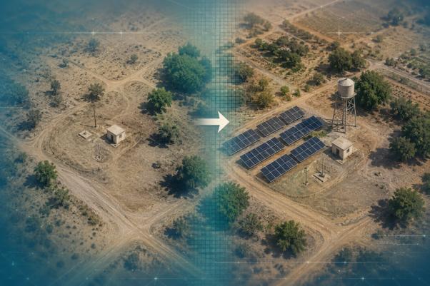
Illustrative: A water tower and solar array visible in high-resolution satellite imagery. In our Yemen evaluation, features like these provided independent evidence of infrastructure implementation in areas where field access was limited.
Most evaluation questions are ultimately about outcomes: whether services are functioning, whether people are using them, and whether interventions are sustained over time.
Satellite imagery contributes to these questions indirectly. It captures visible, physical change, which can then be interpreted as evidence of implementation when it aligns with what a program is expected to deliver.
A visible structure does not in itself demonstrate a working service. A solar array may suggest a pumping system was installed, and a storage tank may indicate expanded capacity, but these observations only become meaningful when they are interpreted in relation to other sources of information.
The strength of satellite imagery lies in its ability to translate visual signals into evidence that is consistent with reported activities, rather than in directly observing program success.
When satellite imagery works well
Satellite imagery is most effective when the evaluation question is framed around detectable physical change.
In our recent WASH evaluation in Yemen, imagery was used to compare pre- and post-intervention conditions across a set of carefully selected sites. The analysis focused on visible infrastructure such as tanks, solar panels, and pump structures, and only included locations where these features could reasonably be identified from overhead.
Under these conditions, satellite imagery provided clear value.
New structures and changes in site layout could be observed over time, offering independent confirmation that construction activity had taken place. When these observations were cross-referenced with site photos and program documentation, they reinforced confidence in the reported implementation and helped resolve uncertainties where field verification was limited.
What made this approach effective was not simply access to imagery, but the alignment between the evaluation question and what the imagery could realistically detect. By focusing on interventions that leave visible traces, the analysis was able to produce evidence that was both credible and interpretable.
Where interpretation matters
Satellite imagery provides a partial view of reality. Using it well requires recognizing that, and then interpreting what it shows carefully. Some interventions, such as underground works or small-scale repairs, do not produce visible changes and therefore fall outside of what imagery can capture. Even when changes are visible, attribution is not always straightforward, and timing differences between construction and image acquisition can affect what is observed.
More importantly, imagery does not provide insight into functionality. A system may be clearly visible and structurally complete, while still facing issues related to maintenance, usage, or sustainability.
Satellite imagery answers a narrower question than evaluators often assume — whether physical changes consistent with implementation are visible, not whether implementation succeeded.
One layer in a broader evidence system
Satellite imagery is most valuable when it is used alongside other sources of data.
In the Yemen evaluation, imagery was treated as one component of a triangulated approach, combined with field photos, local reporting, and program documentation. This allowed visual observations to be interpreted in context, strengthening findings where sources aligned and highlighting areas of uncertainty where they did not.
In this role, satellite imagery contributes to evaluations in three important ways. It provides an independent check on reported activities, helps extend coverage into areas where field access is constrained, and adds a temporal dimension that allows evaluators to observe change over time.
Its value is not in replacing other methods, but in reinforcing and connecting them, making the overall evidence base more robust.
Reframing the Question
Rather than asking whether satellite imagery can verify a project, the more productive question is: what observable signals the project is expected to leave?
This reframing encourages clearer thinking about both interventions and evidence. It requires considering whether the expected change is visible, whether it can be detected at the available resolution and timing, and what additional information is needed to interpret it meaningfully.
In fragile and hard-to-access contexts, where direct observation is often not possible, this kind of evidence-based approach allows satellite imagery to play a meaningful role in building credible evidence.
Used in this way, satellite imagery does not attempt to answer every evaluation question. It strengthens the ones it is best placed to address — and that, in environments where perfect evidence is rarely available, is enough. Satellite-derived data also extends beyond visual imagery. Spectral signals, nighttime lights, and increasingly frequent observations from modern constellations offer additional opportunities for monitoring in fragile contexts — an area where evaluation practice is only beginning to explore.
Frank Salet is part of the Apricity team. This piece draws on experience gained through that work but reflects their own views and conclusions and does not necessarily represent the views of Apricity.